
Being right is everything.
Viewport3 was founded in 2017 and we have implemented our pioneering spirit into all project we undertake. In our short tenure, we’ve worked in all of the world’s oceans and have complete several ‘world-first’ 3D scanning campaigns.
Following each campaign, we’ll answer your pre-project queries by way of an inclusive report that is carefully focussed on answering your original questions in the simplest manner possible. You won’t need an engineering degree to understand our answers.
Our team is experienced in all 3D data collection methods. During photogrammetry projects we can work with your cameras, our cameras, or hired cameras. We can action sub-millimetric, high-detail 3D scanning as well as ‘quick-pass’ high-level data for larger sites or less demanding scanning needs.
In emergencies, we can direct you in collecting valuable data using whatever camera is available at your worksite. In some cases, we can even work with old or ‘legacy’ images and video to help you peek into past conditions.
We provide a bespoke service producing anything from a dimensional report, simple 2D CAD or a full 3D point-cloud output.


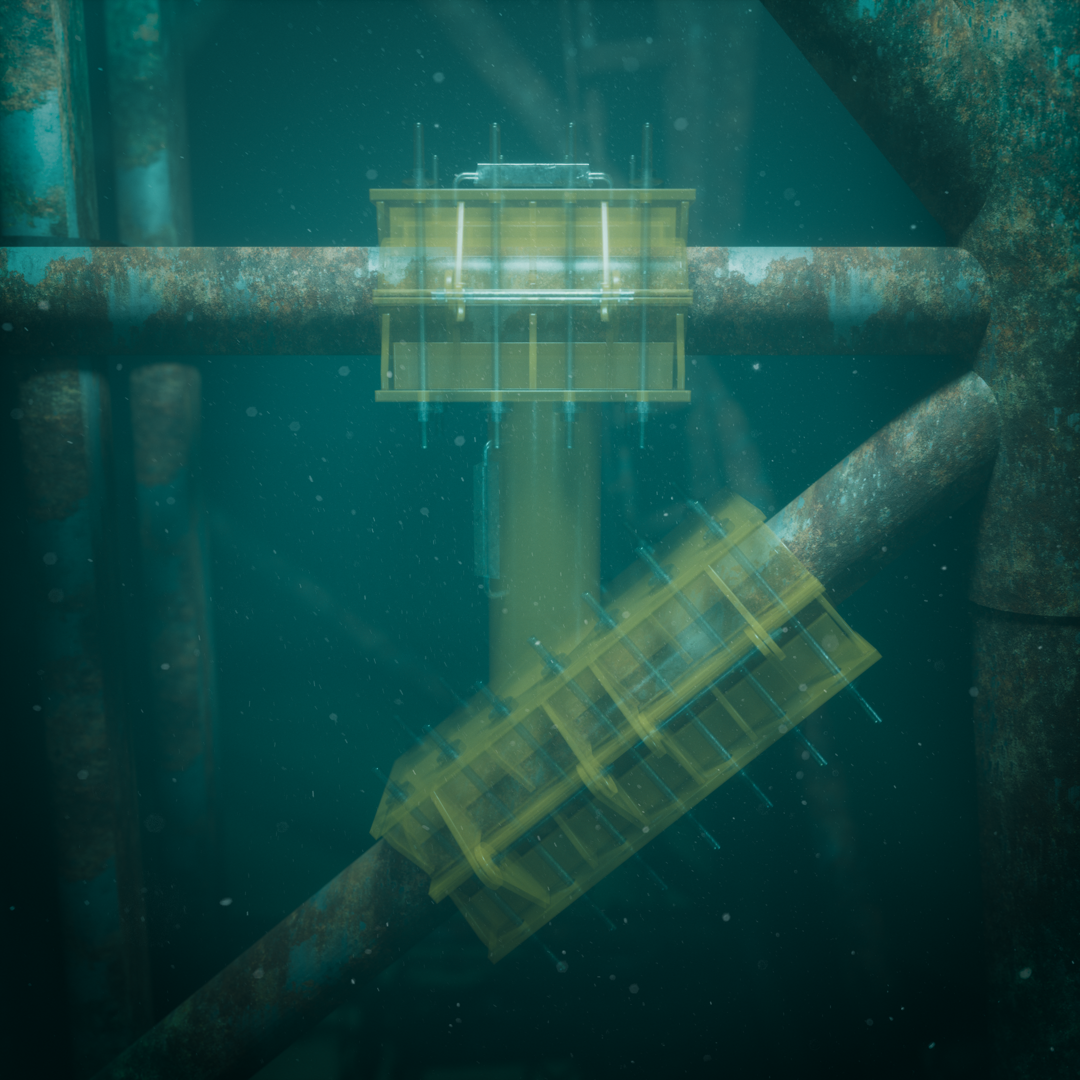
Photogrammetry is a technique used to create technically precise 3D models of physical objects and environments by photography. The process compares information found in a series of images in order to understand its geometrical properties via high-speed trigonometry. This allows the reconstruction process to place each pixel in 3D space, gradually building up a true, accurate and interrogable version of your technical challenge.
Reverse engineering is commonly interpreted as the process of reproducing an item for which no manufacturing information exists. At Viewport3 and in the context of physical objects, we define reverse engineering as the act of taking dimensions from physical objects (the opposite of traditional engineering, where dimensions are given to objects). Once a 3D model is created, it can be used to extract critical information about the geometry of the object and digitally recreate it to meet a customer’s requirements.
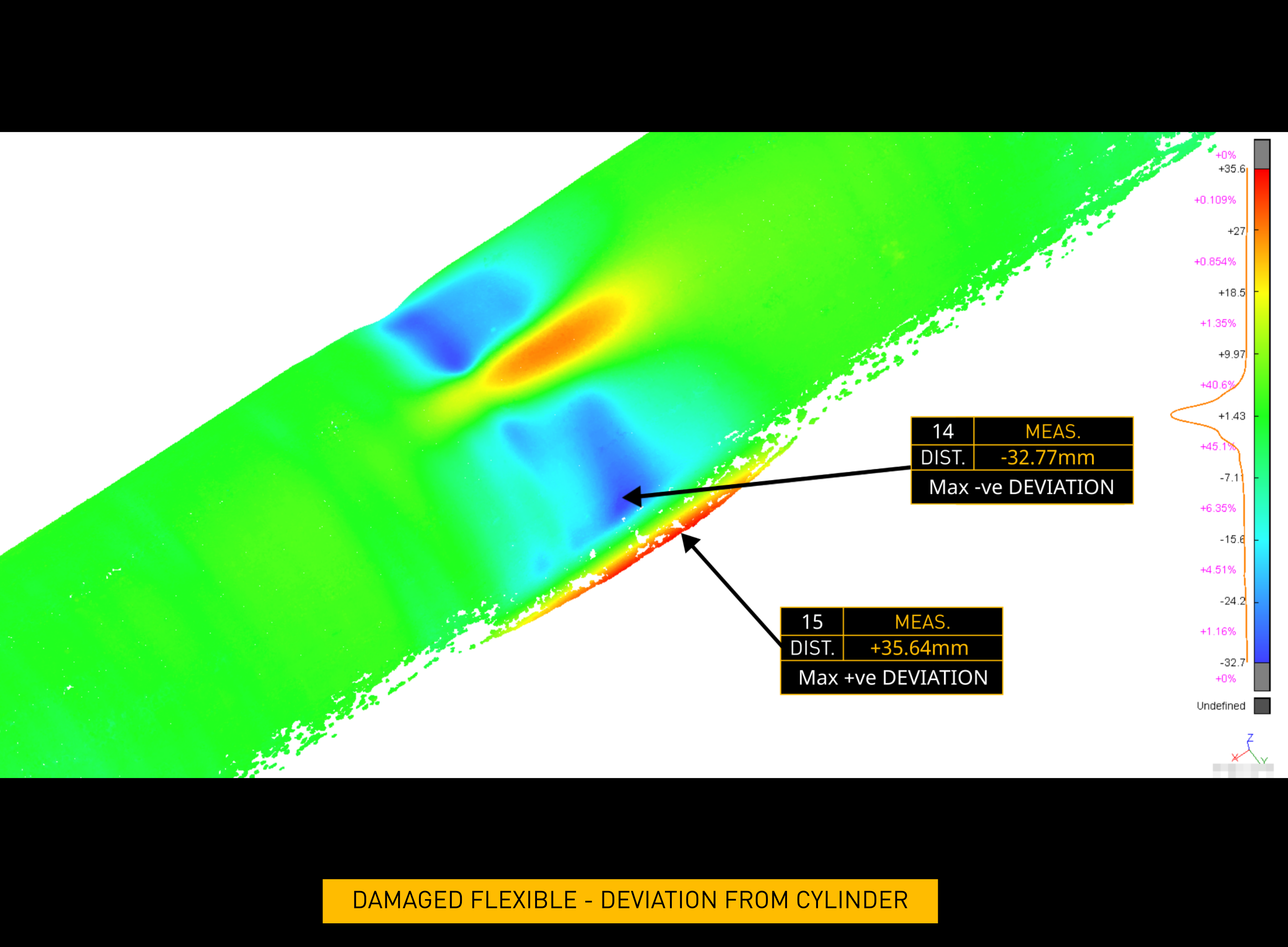
In the context of our work, dimensional analysis describes the process of interrogating a piece of virtual 3D data to answer the questions asked by our customers. In simple instances, it can involve collecting critical dimensions from a mooring link or a wellhead. In more complex examples, dimensional analysis can be used to assess the presence of any ovality on a pipeline or to detail the effect of a foreign object collision.
For geometries that cannot be adequately described by point-to-point measurements, deviation mapping is often deployed, allowing 3D scan data to be compared to a primitive version of itself (such as a flat plane or cylinder), its original design, or even a 3D scan version of itself which was collected at a different point in time (propagation monitoring. Using colour-coding to ‘paint’ the magnitude of the differences onto the object itself, deviation analysis offers a method of understanding a piece of geometry which can be surprisingly instinctive.
On multiple occasions, we have provided 3D data that was used by our customers to design retro-fit hardware that fitted at the first time of asking, saving millions of pounds and in our opinion, demonstrating the accuracy and reliability of the data obtained from well-performed 3D photogrammetry. Simply put us in touch with the responsible designer and we’ll discuss the best 3D data format to suit your incumbent design software.
Our most common work arrangement is to be sat alongside your ROV pilot, requesting specific movements and controlling the camera which has been selected as best suited to your technical stipulations. We can also provide this support remotely, and of course work with diver-systems, aerial drones, crawlers or of course the people at your worksite. Whatever the method or capture system, we have a solution to suit.
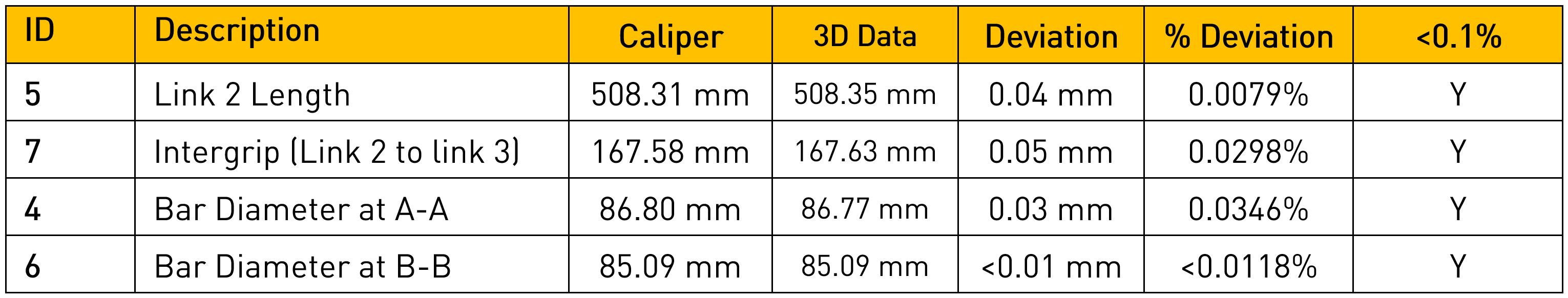
Our scanning methods provide the most accurate data-sets achievable and enable a service that is satisfying the most stringent of customer demands. During our trials for Lloyds Register we demonstrated a maximum error of 0.03% / 0.05mm, which was later certified through our being the first UK company to receive R.I.T.S. certification for photogrammetry work. In a wider sense, the accuracy stipulation for any given project is customer-defined, and is a result of discussion on the intended use of the data. For most technical concerns, a ‘no-compromise’ approach is taken to ensure the information delivered is as accurate as possible. Less demanding requirements such as scour assessment or 3D data for familiarisation can of course allow some flexibility in the specification of the hardware deployed.
Of course. You’ll understand that we can’t publish results from all projects, but we’d be happy to walk you through previous tasks that are relevant to your need and describe work methods and results that are the same as, or most closely related to the solution you need.
Chris, originally from Shropshire, demonstrated his engineering talent early on, winning a Young Engineers for Britain regional final with his design of an underwater air-powered diver’s torch. He later manufactured this design for his final year project at Plymouth University. An award-winning photographer, Chris integrates his photography skills with his passion for diving.
Chris has built a career in the global diving industry, serving as a senior underwater inspection engineer for a multinational subsea service provider. He expanded his expertise into thermal imaging, applying it across marine vessel, distilling, and brewing sectors. His career took a significant turn during his participation in the Elevator accelerator programme, where he partnered with Richard to embark on a new professional journey.
Educationally, Chris holds a first degree in Mechanical Design and Manufacturing and a Master’s degree in Offshore and Ocean Technology from Cranfield University. He is also 3.4u qualified, emphasizing his proficiency in underwater inspection. Known for his technical proficiency and creative approach, Chris combines engineering and photography to innovate and solve challenges.
Richard Drennan, Aberdeen-born and bred, is deeply passionate about automotive technology and photogrammetry.
His expertise spans subsea control systems, additive manufacturing, prototyping, and 3D-based design. Within a 14 year period, Richard advanced from trainee technician to senior engineer with one of Norway’s largest service companies and now boasts 27 year experience in the subsea engineering sector. Transitioning to commercial roles, he founded an additive manufacturing business, collaborating with Aberdeen’s leading firms.
Richard holds vocational qualifications that underscore his technical and commercial expertise. Known for his customer-centric approach, he engages in lively client discussions and explores R&D cameras for innovations. Outside work, Richard restores an ’80s sports car and pursues his interest in the history of science and exploration.


